September 29, 2026
Blogs

For commercial ships, proper positioning, navigation, and timing are essential for safe and efficient operations. GNSS systems serve as one of the major sources of data, but they may be subjected to interference, which in turn impacts the signals from GNSS satellites. In case of any interference, it becomes important for the vessels to ensure proper positioning.
At KDU World, we offer A-PNT (Assured Positioning, Navigation & Timing) solution that would help in navigation continuity in case of any interference to the GNSS. We utilize independent satellite verification through our A-PNT system.
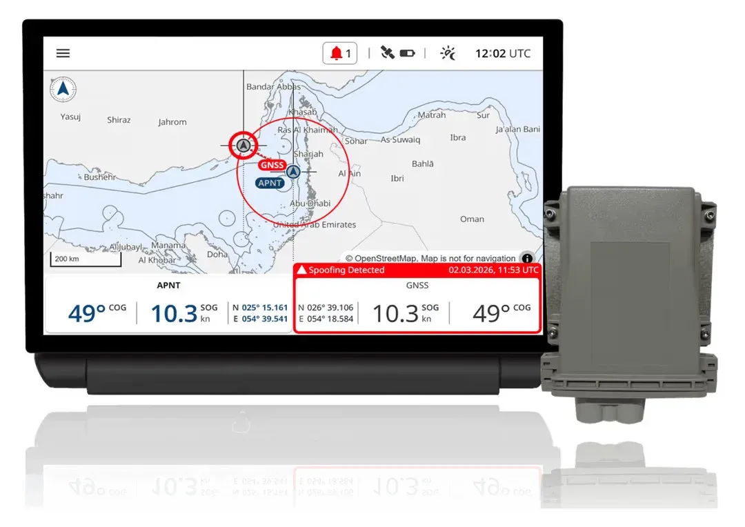
A-PNT solution provides satellite-based validation beyond GNSS. It uses an independent satellite source to help verify the vessels position against GNUS-derived information. The solution provides an additional reference for identifying inconsistencies during GNSS interruptions.
This is particularly relevant when a vessel operates in an area affected by GNSS interference. Instead of relying solely on the availability of a conventional GNSS position, the navigation system can use an additional source to support position verification and continuity.
Timing is an important part of A-PNT alongside positioning and navigation. GNSS provides a precise time reference used by many systems, and a loss or manipulation of that timing information can affect systems that depend on synchronization. A resilient A-PNT architecture therefore considers timing as well as position. Alternative timing references and sensor-based approaches can help maintain reliable timing when GNSS is
unavailable. For vessels with multiple systems relying on accurate A-PNT information, maintaining timing continuity can help support consistent system operation during GNSS disruptions.
An A-PNT solution is designed to address the practical challenge of maintaining trusted positioning when GNSS signals are interrupted.
Positioning plays a very critical role in marine navigation. There have been cases of GNSS jamming that are increasing the threat to the maritime industry; such incidents require a risk assessment and the implementation of resilience against PNT risks. A-PNT serves the purpose of checking the accuracy of the position provided by GNSS.
Vessels operating in busy shipping routes, ports, and other challenging environments may encounter GNSS interference. Jamming can prevent a receiver from obtaining usable signals, while spoofing can provide misleading positioning information. An A-PNT solution is designed and tested for demanding maritime environments. By providing satellite-based validation beyond GNSS, it helps vessels maintain navigation continuity and reduce operational risk when conventional GNSS positioning is challenged.
Supporting Resilient Marine Navigation With A - PNT
At KDU World, we provide A-PNT solutions for marine navigation applications in the UAE. Our solution goes beyond conventional GNSS by providing independent satellite verification to help vessels maintain true position during GNSS interruptions. The A-PNT solution helps:
● Maintains true position during GNSS interruption
● Satellite-based validation beyond GNSS
● Designed and tested for demanding maritime environments
As an authorized marine equipment supplier in the UAE, KDU World provides navigation equipment and solutions for commercial maritime applications where reliable positioning, navigation and timing are essential.
Find more information about A-PNT on our official LinkedIn page.
Keep Reading